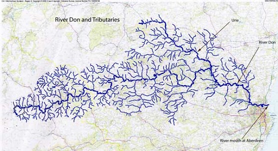
The map above, kindly prepared by River Superintendent Jim Kerr, shows approx . 80 miles of the main river stem which, as can be seen, also has many miles of feeder burns, many of which represent opportunities to improve the environment and fish stocks. In due course further detail will be added to the map linking to ongoing and future projects.
There are approx. 10 other River Dons in the world but we know ours is the best!
The Grampian Mountains or Grampians are one of the three major mountain ranges in Scotland. The name Grampians is believed have first been applied to the mountain range in 1520 by the historian Hector Boece, a transliteration of the Roman Mons Graupius, recorded by Tacitus as the site of the defeat of the native Caledonians by general Gnaeus Julius Agricola (his father-in-law) circa 83 AD.
The River Don is located in the north east of Scotland. It rises in the Grampian Mountains beneath in the shadow of Glen Avon, flowing down to Cock Bridge, flows eastwards to enter the North Sea at Aberdeen
The chief tributaries are Conrie Water, Ernan Waterr, Water of Carvie, Water of Nochty, Deskry Water, Water of Buchat, Kindy Burn, Bucks Burnn, Mossat Burn, Leochel Burn and the River Urie.
|